
Costa Rica’s climate: some final details
Throughout this series of articles, we’ve explored Costa Rica’s climate. Costa Rica’s Climate first article we discovered the main factors that influence Costa Rica’s climate: the intertropical convergence zone, the oceans, the mountains and the volcanoes. ‘Costa Rica’s climate: two seasons – but how?’ was the subject of a second article, we studied the influence of the Caribbean Sea and the Pacific Ocean on Costa Rica’s climate. We also learned how to understand Costa Rica’s climate in relation to your trip.
In this third installment, we’ll explore in depth how the Pacific coast and mountains behave in relation to Costa Rica’s climate.
Costa Rica’s climate: Pacific humidity gradient
We’ve already mentioned that the Pacific rainy season arrives in the South in mid-April, while the Guanacaste region receives its first showers in early June. But why is this?
To understand this, we need to look back at the geography of the Pacific coast, and go back in time to the appearance of the first landmasses. Indeed, 200 million years ago, an inter-oceanic channel separated the north of present-day Nicaragua from the north of South America. Gradually, a line of volcanoes began to emerge. These ancient volcanoes gave rise to the 4 Pacific peninsulas, and we can see them today as small rounded hills that have undergone 200 million years of erosion.
Outer island arc
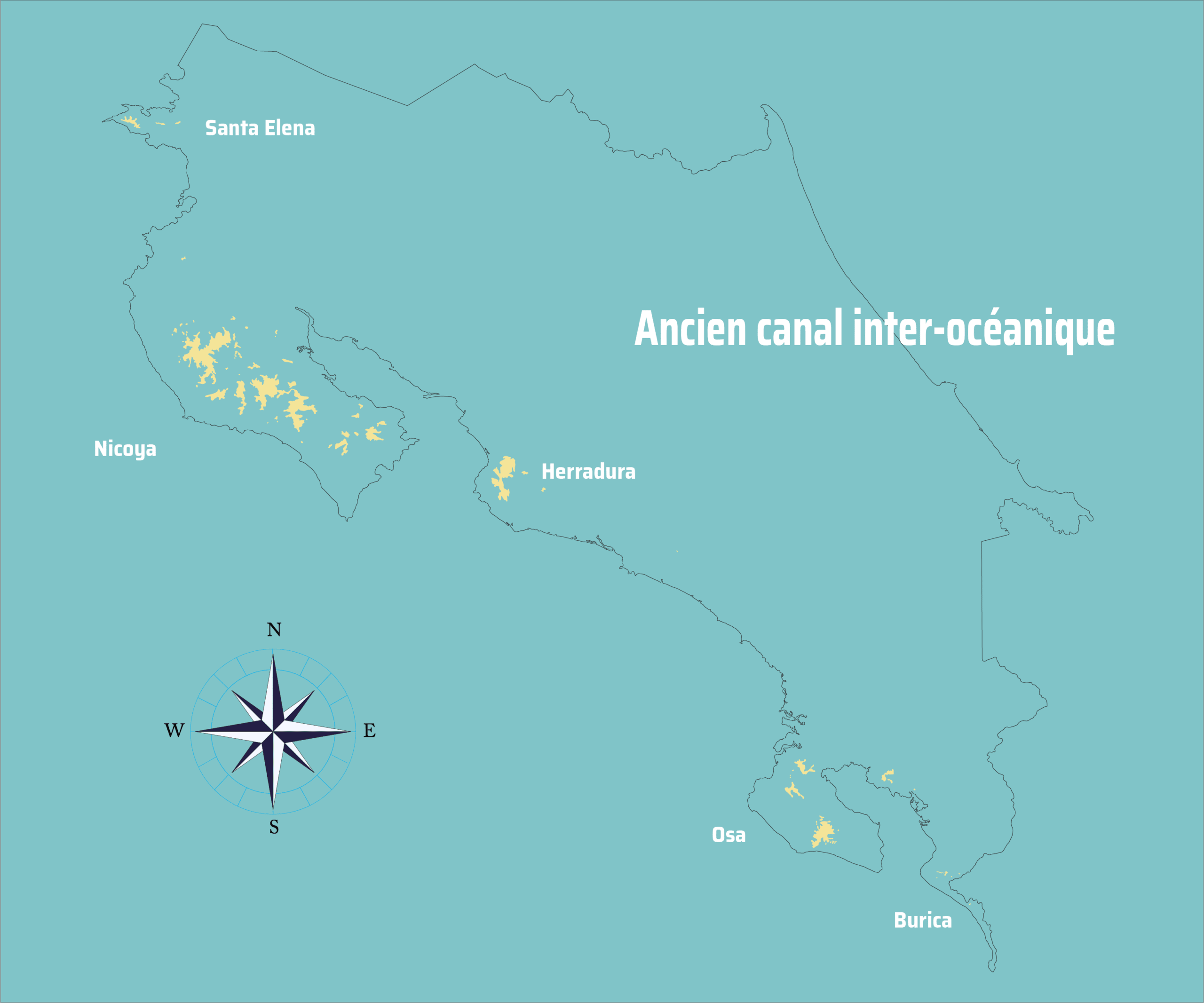
- Santa Elena Peninsula (in the far north, near the Nicaraguan border).
- Nicoya Peninsula (today home to Santa Teresa, Malpaís, Tambor, Paquera, Naranjo and Lepanto).
- Herradura Peninsula (Tarcoles, Jacó)
- Osa Peninsula (home to our beloved Corcovado)
- Burica Peninsula (which forms the border with Panama)
These ancient volcanoes have served as wind redirection points throughout Costa Rica’s history. Moist winds arrive in Costa Rica from the south, from the Pacific, with the migration of the inter-tropical convergence zone in April. These first light winds unload on the southern coasts and gradually rise northwards. When they reach the Nicoya Peninsula, they are discharged into the Nicoya mountains, keeping the northern coasts and plains of Guanacaste free of rain during May.
It’s a phenomenon that can be observed in terms of biotopes along the Pacific.
Biotopes along the Pacific
- Guanacaste: Tropical Dry Forest
- Central Pacific: Tropical Wet Forest
- South Pacific: Very Wet Tropical ForestDuring a trip to the Pacific during the dry season, it’s very interesting to observe the different adaptations of the same species throughout the Pacific, depending on the biotope in which it’s found.For example, in the north, the huge ficus trees spread out lengthwise to capture as much groundwater as possible. The same species in Corcovado spreads out at altitude to capture as much light as possible.
Tip for the hikers
If you’re looking for a multi-day trek in Corcovado National Park, it’s best to plan it between December and April to avoid bad weather. If you don’t mind bad weather, it’s also possible between April and August: it will rain, but the temperature will be more pleasant and the scenery more “dramatic”. Between September and November, it’s best to avoid trekking to Corcovado.
Day visits to Corcovado can be made at any time of year.
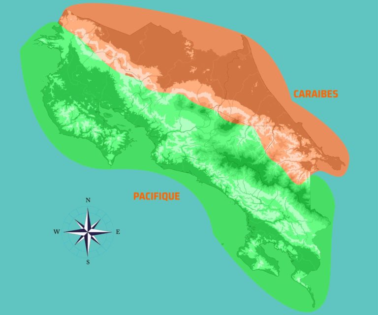
Costa Rica’s climate: How mountains and volcanoes behave
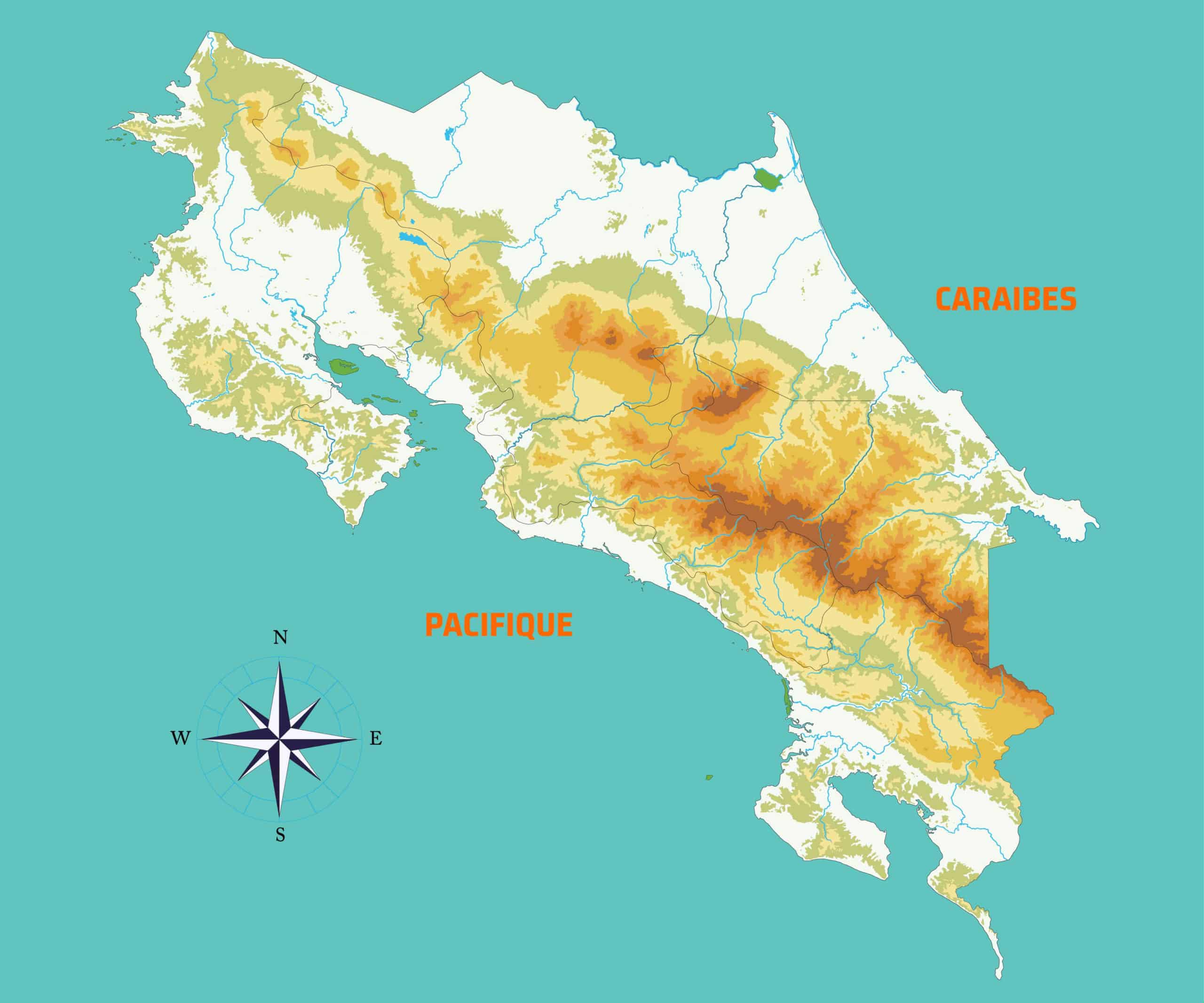
As a general rule, precipitation occurs in the middle elevations of Costa Rica’s mountains and volcanoes (~1000 m). In fact, from mid-altitudes upwards, mountains and volcanoes gradually rise to this level, then become isolated peaks and mountain passes that prevent the rising winds from crossing them.
This is not to say that it doesn’t rain from 1000 m upwards. But heavy precipitation is cumulative
Convective thunderstorms exist on the Caribbean side of volcanoes and mountains. These are created by the collision of warm air masses from the Caribbean, which cool down as they hit the mountain ranges and are thrown back onto the plains and foothills. This is one of the reasons for the instability of the Caribbean in relation to the Pacific.
Tips for hikers
The high mountains and volcanoes are influenced by both the Caribbean and the Pacific. That’s why it’s so difficult to predict good weather when hiking in Chirripó National Park or La Amistad International Park.
Indeed, for good weather to occur in these mountain ranges, the Caribbean and Pacific weather conditions must be optimal, which is rarely the case. March is one of the best periods in this respect, but there is no guarantee that conditions will be as good as desired.
There is one isolated case in the Talamanca mountain range: Cerro Kamuk (3554 m). Access to this mountain is via the Pacific (Tres Colinas de Potrero Grande), but the Kamuk massif is almost entirely under the influence of the Caribbean. For this reason, the months of March and October are ideal for climbing.
However, I’d advise all mountaineering enthusiasts to arm themselves with suitable clothing and plenty of patience. The Cordillera de Talamanca always surprises, both positively and negatively.
Read more about the orogeny of Costa Rica on GeoScienceWorld
Découvrez d’autres articles de blog


Pourquoi voyager avec nous ?
Une réputation sans faille depuis 2008
Un seul interlocuteur en français
Notre présence toute l’année sur le terrain
Notre expertise pour une offre sur mesure